


How the Weather Got ‘Stuck’ Over the UK, Creating an Unusually Dry and Warm Spring in 2025
Spring 2025 has been marked by extraordinary weather across the UK, characterized by record-breaking dryness, warmth, and sunshine. Meteorologists attribute this unusual pattern to a persistent high-pressure system that effectively “got stuck” over the region, blocking typical Atlantic weather fronts and creating a prolonged spell of settled, dry conditions. This spring has become the driest in more than 170 years and one of the sunniest on record, with temperatures consistently above average.
Record-Breaking Dryness and Warmth Across the UK
Rainfall Deficits and Temperature Anomalies
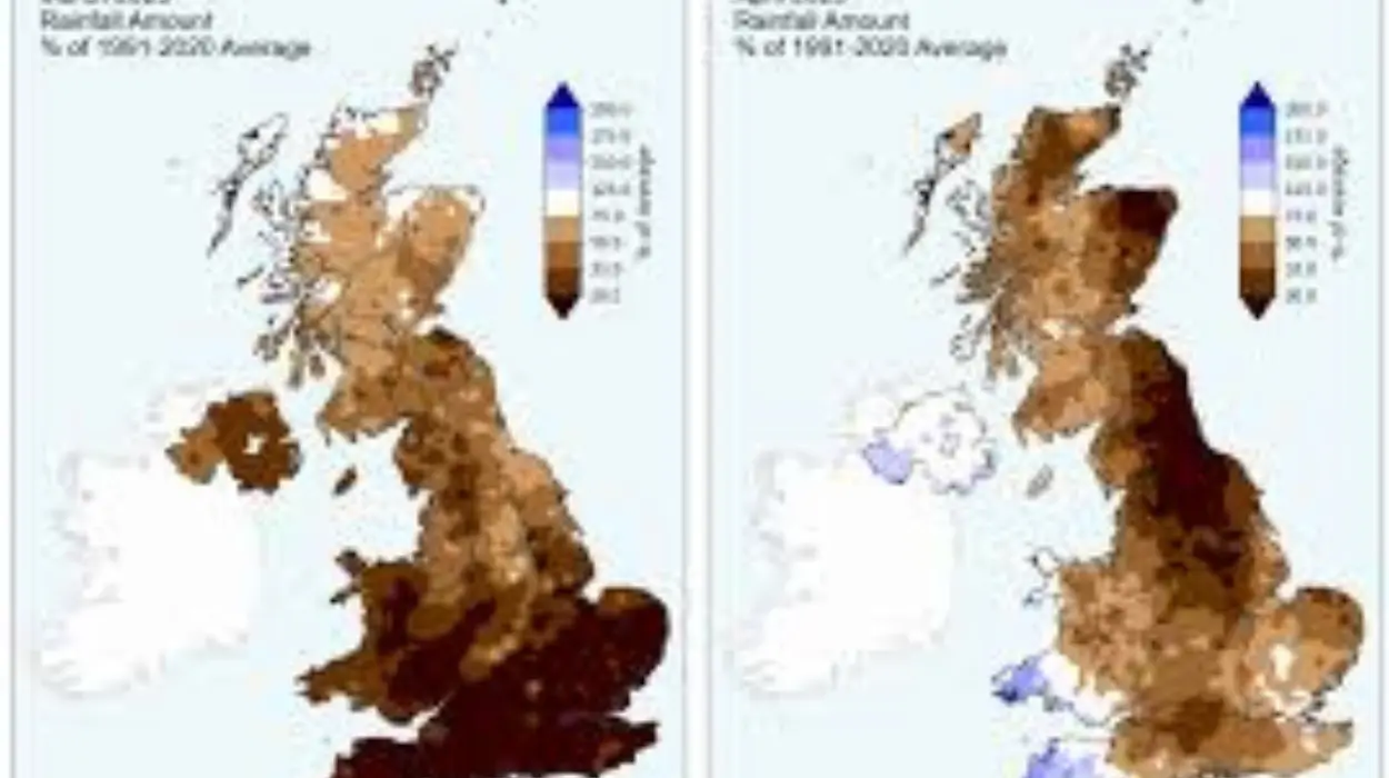
The UK has experienced an unprecedented lack of rainfall this spring, with total precipitation measuring just 80.6 mm so far-making it the driest spring since records began in 1852, when 100.7 mm was recorded. This stark deficit has been accompanied by warmer-than-average temperatures:
- The mean temperature for spring 2025 is 8.77°C, which is 0.69°C above the 1991-2020 average, ranking it as the eighth warmest spring since 1884.
- March 2025 was the sunniest March ever recorded in the UK, followed by April 2025, which also set records as the sunniest April on record.
- England recorded its fifth sunniest spring, while the UK overall ranked eighth in sunshine hours.
Sunshine Hours and Seasonal Comparisons
- March delivered 158.1 hours of sunshine, 145% of the long-term average, making it the third sunniest March on record.
- April saw 228.9 hours of sunshine, 147% of the long-term average, marking the sunniest April ever for the UK and England.
- Total sunshine hours for spring 2025 have reached 507, significantly higher than typical seasonal averages.
Meteorological Causes: The ‘Stuck’ Weather Pattern
Persistent High-Pressure System
The dominant factor behind this unusual spring weather has been a high-pressure system that remained nearly stationary over the UK and surrounding areas for much of March and April. This phenomenon, known as a “blocking high,” prevented the usual Atlantic low-pressure systems from bringing rain and cooler air to the region.
- The high-pressure system created stable atmospheric conditions, reducing cloud cover and allowing more sunlight to reach the surface.
- This stability also limited the passage of weather fronts, resulting in significantly reduced rainfall across much of England and Wales.
Influence of La Niña and Atmospheric Patterns
Climate scientists link the persistence of this high-pressure system to the ongoing La Niña event in the Pacific Ocean, which typically shifts the jet stream northward and reduces the frequency of Atlantic storms reaching the UK, especially during spring.
- The jet stream’s altered path has contributed to the prolonged dry and warm conditions experienced in southern and central England.
- Northern Ireland and parts of Scotland saw slightly more rainfall but still remained below average overall.
Climate Change Amplification
Experts emphasize that climate change has increased the likelihood and intensity of such warm and dry spells:
- The Climate Shift Index (CSI) indicates that human-induced climate change made the unusually high spring temperatures in parts of the UK at least three to five times more likely.
- Between April 27 and 30, 2025, approximately 42 million people in the UK experienced temperatures significantly above normal, with anomalies of 6 to 8°C recorded in cities like Middlesbrough, Newcastle, and Blackpool.
Regional Variations and Environmental Impact
Rainfall Distribution
- Northern Ireland recorded 84.8 mm of rainfall in April, 114% of the long-term average, making it the wettest UK region during the month.
- Scotland also experienced slightly above-average rainfall compared to southern regions.
- Central and southern England faced the most severe rainfall deficits, exacerbating drought concerns.
Agricultural and Ecological Effects
- The dry weather has been beneficial for spring planting and outdoor activities but raises concerns about soil moisture and drought stress if the dry spell continues.
- Water companies have issued warnings about reservoir levels and urged conservation measures.
- Increased sunshine and dryness have heightened wildfire risks in rural and forested areas.
Outlook for Late Spring and Early Summer 2025
Meteorological forecasts suggest that:
- Temperatures are expected to remain above average through late May and into early summer.
- Rainfall will likely continue to be below normal in southern and central parts of the UK, with a chance of wetter conditions returning to northern areas.
- The blocking high-pressure system may weaken or shift, potentially allowing more variable weather patterns later in the season.
Summary
Spring 2025 in the UK has been characterized by record-breaking dryness, warmth, and sunshine, driven primarily by a persistent high-pressure system that “got stuck” over the region. This unusual weather pattern has led to the driest spring in over 170 years, with significant implications for agriculture, water resources, and wildfire risk. Climate change has amplified these extremes, making such events more frequent and intense. While the dry and sunny conditions have been welcomed by many, the long-term outlook calls for vigilance as the UK moves into summer.